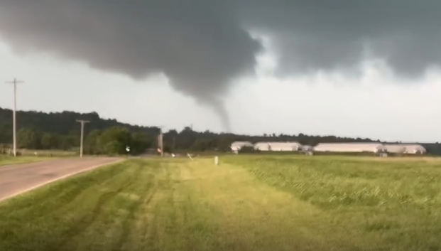
SYCAMORE, Kan. — A Particularly Dangerous Situation (PDS) Tornado Warning has been issued for parts of southeast Kansas as a large and potentially destructive tornado moves through northern Montgomery County. According to emergency alerts, a multi vortex tornado was observed near Sycamore and is now tracking east southeast at approximately 25 mph, placing communities including Sycamore, Independence, and Cherryvale directly in its path.
As of the latest update, the tornado was located about 2 miles west of Sycamore and moving into the area. Meteorologists warn that the storm has become rain wrapped, significantly reducing visibility and making it extremely dangerous for anyone attempting to see it.
The Warning: A Particularly Dangerous Situation
The National Weather Service has issued a PDS Tornado Warning for this storm. A PDS warning is the most urgent type of tornado warning issued by the National Weather Service. It is reserved for situations where a large, violent, and potentially deadly tornado is imminent. This is not a routine warning. This is a call to take immediate action.
The tornado is moving into Sycamore, Kansas, a small town in Montgomery County with a population of approximately 200 residents. It is a rural community of homes, farms, and open land. The tornado is also threatening the larger communities of Independence and Cherryvale. Independence is the county seat of Montgomery County, with a population of approximately 8,500 residents. Cherryvale is a smaller city of approximately 2,000 residents.
The tornado is moving east southeast at approximately 25 mph. That is a relatively slow forward speed. Slow moving tornadoes can be especially dangerous because they remain on the ground longer, causing more damage over a larger area. The storm is rain wrapped, meaning that the tornado is hidden behind a curtain of heavy rain. This makes it impossible to see. People in the path may not see the tornado coming until it is upon them.
The Tornado: Multi-Vortex and Large
The tornado has been described as a multi vortex tornado. A multi vortex tornado contains multiple small suction vortices rotating within the main funnel. These sub vortices can cause pockets of extreme damage, even within the broader path of the tornado. Multi vortex tornadoes are often associated with the strongest and most violent storms.
Meteorologists have also described the tornado as large. The exact width has not been specified, but a large tornado can be hundreds of yards wide, or even over a mile wide. A large tornado can level homes, toss vehicles, uproot trees, and destroy entire neighborhoods.
The tornado was observed near Sycamore. Observers may have been storm chasers, trained weather spotters, or residents who saw the funnel. As the storm has become rain wrapped, visual observation is no longer possible. Radar indicated rotation and debris signatures are being used to track the tornado.
The Path: Sycamore, Independence, Cherryvale
The tornado is moving east southeast, directly toward Sycamore. Residents in and around Sycamore should be in their shelters now. There is no time to evacuate. The tornado is 2 miles west of the town and moving at 25 mph. At that speed, it will reach the town in approximately 5 minutes.
After passing through Sycamore, the tornado is expected to continue toward Independence and Cherryvale. These communities are larger. More people are at risk. Emergency alerts have been sent to cell phones in the area. Sirens are sounding. Residents are being told to take cover immediately.
A tornado of this size and intensity can cause catastrophic damage. Homes can be leveled. Businesses can be destroyed. Trees can be uprooted. Power lines can be downed. Vehicles can be tossed like toys.
The Danger: Rain Wrapped
The greatest danger at this moment is that the tornado is rain wrapped. Heavy rain surrounding the tornado makes it impossible to see. People who are outside, or who are looking out their windows, may not see the tornado coming. They may not realize they are in danger until the storm is on top of them.
Rain wrapped tornadoes are especially deadly. They provide no visual warning. The only warning is the alert on your phone, the siren in your town, or the radio broadcast. Do not rely on your eyes. If you are in the warned area, take shelter now.
The Response: Take Shelter Immediately
Residents in the path of this tornado are urged to take shelter immediately. Go to a basement, a storm cellar, or an interior room on the lowest floor of a sturdy building. Stay away from windows. Cover your head and neck. If you are in a mobile home, abandon it immediately and seek shelter in a nearby sturdy building. Mobile homes offer no protection in a tornado.
If you are driving, do not try to outrun the tornado. Tornadoes can change direction and speed. Instead, pull over and find a low lying area such as a ditch. Lie flat and cover your head. Do not seek shelter under an overpass or a bridge. These can become wind tunnels and are extremely dangerous.
The Aftermath: What Comes Next
As the tornado moves through the area, damage assessments will begin. Emergency responders will search for injured residents. Utility crews will work to restore power. The National Weather Service will send storm survey teams to assess the damage and determine the tornado’s rating on the Enhanced Fujita Scale.
The storm may produce additional tornadoes as it continues east. This is a dangerous situation. Stay tuned to local weather broadcasts, NOAA weather radio, or reliable online sources for updates.
Holding Onto Hope
For those in the path of this tornado, the next few minutes will be terrifying. The wind will roar. The pressure will drop. The building may shake. Debris may fly. But if you are in a safe shelter, you have a good chance of surviving.
After the storm passes, check on your neighbors. Look for injured people. Avoid downed power lines. Stay out of damaged buildings. And be thankful that you survived.
Conclusion: A Deadly Storm Approaches
A large and dangerous PDS tornado is moving into Sycamore, Kansas, and will continue toward Independence and Cherryvale. The tornado is rain wrapped, making it impossible to see. Residents in the warned area should take shelter immediately. This is a life threatening situation.
As the storm passes, the community will come together to recover. But for now, the only priority is survival. Take cover. Stay safe. And may everyone in the path of this storm find shelter in time.
Leave a Reply